On Saturday July 10, the Route 66 Association of Missouri held a meeting in Richland at The Cave Restaurant and Resort. Any time we have a meeting that is anywhere near Rolla, several of us end up staying the night at Zeno’s and making a weekend out of it. I was in the mood to actually get my mountain bike dirty for a change, so I consulted my copy of the book Show Me Mountain Biking to see if there were any suitable trails near Rolla. I decided to try the Kaintuck Hollow Trail in Mark Twain National Forest, near Newburg. I printed out a forest service map to take with me since the network of trails looked like it might be challenging to navigate without getting lost.
On Sunday morning, after mass at St. Patrick’s and a hearty and delicious breakfast at Cookin’ From Scratch in Doolitle, my brother Larry and I headed for the trail. Since Larry does not have a mountain bike, the plan was to park at the second parking area past the Mill Creek Recreation Area and for Larry to walk part of the way while I biked on ahead of him. He had brought a book to read while waiting for my return, and the first parking area looked like a much more pleasant place to rest and read a book, so when he was done walking he moved my Jeep to the first parking area.
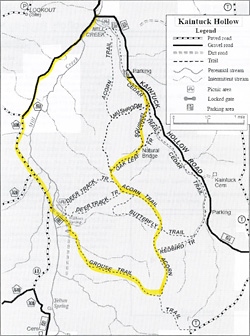
Here is a scan of the forest service map marked in yellow to show the (probable) route I ended up taking. Click on the thumbnail to see a larger image.
I encountered water on the trail right away. I’m not afraid to get my mountain bike wet, but some of the water was muddy so I walked the bike through to avoid splashing myself with muddy water. The first segment on the Cedar trail was lovely, a nice easy ride with wildflowers all around. That soon changed when I turned onto the Squirrel trail and started to climb uphill. I don’t mind admitting that this portion was WAY beyond my ability and I walked the bike uphill. I don’t see how anyone could ride a bike up this part – the trail here was mostly washed out ruts with fist sized rocks and loose gravel. But apparently people do – I saw some red paint on a rock from someone wiping out, I presume. Even walking the bike up was not easy.
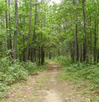
Once on top of the ridge, the trail became quite rideable and lots of fun. The terrain here was mostly hard packed dirt or small gravel with an occasional rock through open glades, oak forest and pine forest.There was occasional sand and mud and frequent fallen branches which for the most part I could ride right over. I had to dismount a few times to get the bike over a log. Occasionally there was a trail marker where two paths met – the trail markers here have little graphical icons indicating what section you’re on, such as an Acorn or a Deer Track – but all the intersections I came across were not marked so for much of the time I was not really sure where I was.
When I started to descend from the ridge, I thought I was on the Redbird trail and I planned to meet the road at the bottom and take it back to the Mill Creek Recreation Area where the Jeep was parked. The long ride down was a highlight of the ride. The trail was not so steep that I feared for life and limb, but steep enough to be challenging and fun. It was necessary to steer very carefully to avoid large rocks and ruts and other hazards, and to avoid building up too much speed. My legs sure appreciated the rest! I was dismayed however when I got to the bottom – there was a trail marker there and it did not look like a Redbird – it looked more like a Grouse! I was on the opposite side of the ridge from where I wanted to be. But at least I knew where I was.
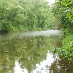
I decided to head for the nearest road and take it back to the parking area even though it was the long way around – ascending that ridge again was too exhausting to contemplate! My dismay soon turned to delight at the interesting scenery around me. There was old silo covered with vines and graffiti and a low water bridge crossing beautiful Mill Creek – this time I rode through the shallow water with no trouble. A mysterious mist hovered over the stream, leading me to believe that Wilkins Spring, which I knew was close from the map, was feeding into the stream nearby.
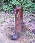
I soon found the road and was back at the parking site much more quickly than I expected. There is an artesian well here with a spigot from which you can get cold, potable water. I got a towel out of the Jeep and made a beeline to the well to wash the sweat, dirt and spiderwebs off of my weary limbs and face. Ahh! I refilled my water bottles and relieved my thirst with the delicious spring water. The three water bottles I brought were barely enough for this trail. What a great way to end a ride! I gave my wrinkled sweat-stained map to a couple who were about to begin their ride since the one they had was not as detailed.
I will be back to this area – there are many interesting features I either missed or want to explore more closely. I highly recommend this trail to anyone who wants a fairly strenuous hike or off-road bike ride and wants to feel like they are in the middle of nowhere and enjoy the beauty of Ozark scenery while only a few miles from the Interstate.


